Geology along Hiromi Line, Meitetsu
This guide is prepared for
understanding geology in some areas along the Hiromi Line of Nagoya Rail
Way. In addition to the Hiromi
Line, some areas along the Komaki Line and the Kagamigahara
Line are also introduced.
Contents
�T History of the
Hiromi Line
�U Outline of geology
�V Zenjino,
Mt. Tsugao, and Tomioka-mae
�W Kanigawa,
Mt. Hatobuki and Nishi-Kani
�X Nihon Rain Imawatari
�Y Shin-Kani and Shimogiri
�Z Akechi
and the Yaotsu Line remain
�[ Mitake,
Mitake-guchi and Godo
�\ Haguro
and Gakuden (the Komaki Line)
�] Shin-Unuma (the Kagamigahara Line)
Summary: Geology along the
Hiromi Line under the geologic framework of Japan
Appendices: Base of geology,
Mineral resources and Sub-surface geology
References
�T�DHistory of the Hiromi Line
The Hiromi Line has one century
history since opening the rail way between Hiromi (Shin-Kani,
now) and Mitake in 1920. The line has a few historical steps such
as extending the rail way and belonging to Nagoya Rail Way.
1900; Establishing National
rail way station Tajimi
1912; Proposal of the rail way
between Tajimi and Mitake
by the local communities
1918; Start the line of Hiromi
(Shin-Kani, now) to Shin-Tajimi
(11.8 km)
1920; Start the line of Hiromi
(Shin-Kani, now) to Mitake
(6.8 km)
1925; Start the line of Inuyama-guchi to Imawatari (12.4
km) by Nagoya Rail Way (Imawatari Line)
1926; The line between Shin-Tajimi and Hiromi was to be managed by Government.
On the other hand, the line of Hiromi (Shin-Kani, now) to Mitake by Tobi Rail
Way.
1928; Start the line of Hiromi
to Mino-Ohta.
Completion of National (JR, now) Taita Line.
The Mitake Line, Tobi Rail Way, was electrified.
1929; Start the line of Imawatari to Hiromi by Nagoya Rail Way, named Hiromi Line
1930; Start the Yaotsu Line by Tobi Rail Way
1943; Tobi Rail Way was merged
to Nagoya Rail Way.
1965; The line of Shin-Hiromi
to Mitake and the Yaotsu
Line were electrically powered up.
The train directly
runs from Nagoya.
1984; The Yaotsu
Line was changed a rail bus system.
2001; The Yaotsu
Line was abolished.
Since 2010; Line of Shin-Kani to Mitake has been supported
by Mitake town and Kani
city.
�U�DOutline of Geology
�P�DIntroduction
The Hiromi Line, Meitetsu
Rail Way, runs from Inuyama to Mitake. Geology along this line consists of
Mesozoic strata of Mino Belt, Cretaceous granite and Upper Cenozoic strata.
This leaflet introduces some excursion
routes for understanding geology.
Each station area has some view points on geology.
Inuyama;
Terminal station for Nagoya Rail Way (Meitetsu).
Tomioka-mae
and Zenjino; Miocene mudstone and Mesozoic chert.
Nishi-kani
and Kanigawa; Miocene volcanic conglomerate and
Mesozoic chert and Manganese mines.
Nihon-Rain Imawatari;
Miocene volcanic conglomerate and tuffaceous
sandstone.
Shin-Kani;
Pliocene gravel and Miocene sandstone and mudstone.
Akechi;
Terminal station of the Yaotsu Line (abandoned
railway). Manganese mine near Yaotsu station.
Godo, Mitakeguchi and Mitake; Pliocene
gravel, Miocene sandstone and mudstone, Mesozoic chert, sandstone and mudstone
and granite.
Table Summary of the geology
|
Geologic
age |
Geologic
division |
Abbr. |
Lithology |
Geological
history |
|
Quaternary Holocene Pleistocene |
Alluvium Gentle
slope deposits Mudflow
deposits Terrace
deposits |
(a) (s) (m) (t) |
Gravel,
sand and mud Gravel,
sand and mud Gravel,
scoria and mud Gravel
and sand |
Alluvial
plain Volcanic
detritus Terrace |
|
Neogene Pliocene Miocene |
Toki
Sandy Gravel F. Nakamura
Formation Hachiya Formation |
(N3cg) (N1ss) (N1v) |
Gravel
and sand Sandstone
and mudstone Pyroclastic
rocks |
Terrestrial Terrestrial Terrestrial
volcanics |
|
Paleogene |
|
|
|
|
|
Cretaceous |
Granite |
(gK2) |
Granitic
rocks |
Felsic
magmatism |
|
Jurassic Triassic Permian |
Mino
Complex Kamiaso
Unit |
(Jms) (Jss) (Jsi) (Jch) |
Mudstone
with clasts Sandstone
and mudstone Siliceous
mudstone Chert |
Melange Sedimentation Sedimentation Sedimentation |
Based
on Yoshida and Wakita (1999).
2�DOutline of geology
This district is
composed of Mesozoic Mino Sedimentary Complex (Mino Belt), Late Cretaceous
granitic rocks, Early Miocene Hachiya and Nakamura
Formations of Mizunami Group, Early Pliocene Toki
Sandy Gravel Formation, Pleistocene terrace deposits and Holocene alluvium deposits. The following description is based on
Yoshida and Wakita (1999).
2�D1 General remarks
The district covers the border area of Aichi and Gifu
Prefectures and is topographically occupied by the Mino Mountains in northern
half and the Nobi Plain in southern half.
The Kiso River runs from northeast to southwest in northern area.
The Mino Mountains consist of Mino Sedimentary Complex
and the Nobi Plain is floored with Middle to Late Pleistocene and Holocene
sediments. Small granitic bodies in
Late Cretaceous age are intruded into the Mino Complex. The Early Miocene Hachiya
and Nakamura Formations and Early Pliocene Toki Sandy Gravel Formation overlie
the complex in the hilly region and underlie Pleistocene and Holocene deposits
in the Nobi Plain.
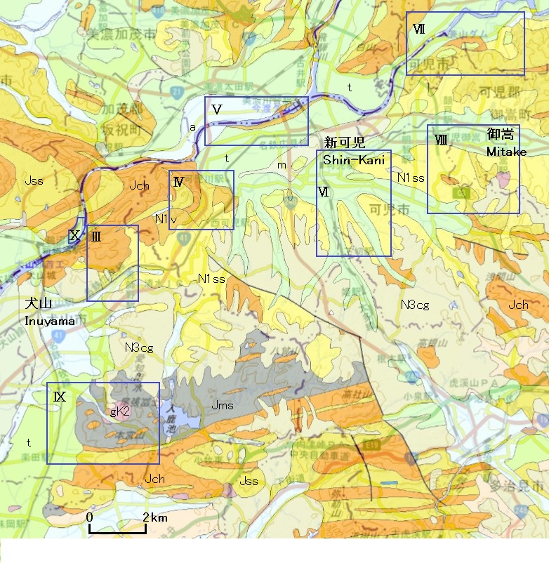
Geologic map based on the
Seamless geologic map of GSJ. The frame
shows the mapped area in each chapter.
2�D2 Geology
Mino Sedimentary Complex
The Mino Sedimentary Complex of
Jurassic to earliest Cretaceous age is the oldest formation in this guide
area. The complex in this guide is
tectonically characterized by the assemblages of the tectonic slices that are
composed of siliceous claystone (Late Permian to Early Triassic), bedded chert
(Middle Triassic to Early Jurassic), siliceous mudstone (Middle Jurassic), the
alternation of sandstone and mudstone and massive sandstone (Middle to Late
Jurassic).
Cretaceous Granite
The granitic rocks crop out
south of Mitake station and east of Haguro station.
They may belong to Cretaceous Naegi Granite,
Sanyo Zone. They may be
petrographically granite to granodiorite.
K-feldspar phenocryst shows ENE-WSW direction and gentle plunge in
lineation structure in Mitake area.
Upper Cenozoic
The upper Cenozoic in this
guide are divided into the Lower Mizunami Group, the
Lower Pliocene Tokai Group, Middle to Late Pleistocene sediments (mostly
terrace deposit), and Holocene alluvial sediments.
The Mizunami
Group is divided into the Hachiya and Nakamura
Formations in ascending order. The Hachiya Formation consists chiefly of andesitic pyroclastic
rocks. The U-Pb age in zircon is 22.38�}0.17Ma in the lowest part of the formation. The Nakamura Formation is mostly
composed of interbedded sandstone and mudstone. These formations are of non-marine
origin.
The upper sediments of the
Tokai Group are of alluvial fan origin and called the Toki Sandy Gravel
Formation. It is composed of gravel
to sandy gravel. Zircon in this
formation gives 3.94�}0.07Ma of U-Pb age and 3.97�}0.39Ma of fission track age.
Middle to Late Pleistocene
sediments can be divided into gravelly terrace deposits and mudflow
deposits. The terrace
deposits are subdivided into a few deposits in the Seamless Geologic Map of GSJ
but will be described as only terrace deposits in this guide. The mudflow deposits may be originated
from the Kiso-Ontake Volcano. Holocene alluvial sediments are made up
of gravel, sand and mud. Most of them are valley bottom plain deposits.
2�D3 Mineral resources
Manganese ore is embedded in
the chert of the Mino Complex.
Small manganese mines were once operated in the mapped area and were all
closed by the end of the 1970�fs.
�V�D Zenjino-Mt.Tsugao-Tomiokamae
General�@
Mesozoic cherty rocks (Jch) crop out in the mountain area including Mt. Tsugao. Neogene
sandstone and mudstone of the Nakamura Formation (N1ss) occur in the foot of
the mountain. Pliocene sediment
layer of the Toki Gravel Formation (N3cg) is widespread overlying the Nakamura
Formation. Terrace deposits are
found in flat plain of the low land.
Alluvium deposits distribute in valley bottoms.
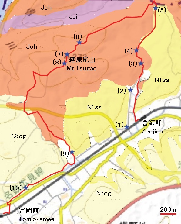
Visit points
(1) The explanation board on
the Kiso Road and the Zenjino Spot.
(2) Milestone of the Kiso Road.
(3) Exposure of chert.
(4) Obora
Pond.
(5) Mudstone of the Nakamura
Formation is exposed on the mountain path.
(6) Bedded chert is exposed
everywhere along the ridge.
(7) Summit of Mt. Tsugao, Triangulation target point.
(8) Tumulus along the mountain
path.
(9) Lignite layer in the
Nakamura Formation.
(10) Sediments of the Toki
Formation crop out in the path.
�W�DKanigawa - Mt. Hatobuki - Nishikani
General
Chert (Jch)
in the Kami-Aso unit of the Mino Complex and
sediments of the Hachiya and Nakamura Formations
(N1v, N1ss) in the Mizunami Group are cropped out in
this area. Besides these terrace
deposits, slope sediments and alluvium deposits are also distributed. Chert contains Triassic and Jurassic radiolarian
fossils but formation of complex established in Middle Jurassic. The Mizunami
Group ranges lower to upper Miocene.
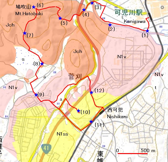
Visit points
(1) The board �gA scenic spot �eDemons�f island�f�h is set on the Tokai nature
pass. Lapilli tuff and tuffaceous sandstone of the Hachiya
Formation are exposed along the Kanigawa River.
(2) The Miocene Hachiya Formation is
contacted with Jurassic chert complex in abut relation. Chert contains manganese mineral
deposits. Some tunnel entrances of
the abandoned mines are found.
(3) Chert layer is exposed at the cliff under the bridge.
(4) A monument for the Dota castle ruin.
(5) Chert is exposed along a path toward Mt. Hatobuki. We can see the closed manganese mine
entrance on the way.
(6) Summit of Mt. Hatobuki.
(7) Chert is exposed along the path from Mt. Hatobuki
to Nishikani station.
(8) Chert is exposed around the grave park. Chert here shows fold structure.
(9) Lapilli tuff of the Hachiya Formation is
exposed along the road in the residence area.
(10) The Neogene Nakamura
Formation is exposed at south of the national road no. 41. Sedimentary structure such as cross
lamination is visible.
(11) Mudstone of the Nakamura
Formation is exposed along the road.
(12) Lapilli tuff (the Hachiya Formation) is piled up to mudstone (the Nakamura
Formation).
�X�DNihonrain-Imawatari
General
The Hachiya
Formation (N1v), Early Miocene, crops out along Kiso-River. It is composed of lapilli tuff and
sandstone containing silicified woods.
Flat plain surface is terrace deposit (t) or alluvium (a).

Visit points
(1) The Hachiya
Formation is distributed over the down side of the Imawatari
Dum.
(2) Sandstone of the Hachiya Formation shows cross lamination under Shin-Ota
Bridge.
(3) The Fossil Grove Park is settled
on the riverbank in Mino-Kamo City.
(4) Silicified wood is well
preserved along left bank of the Kiso River, Kani
City.
(5) Tuff breccia of the Hachiya Formation is exposed under the Chuno-Ohashi
Bridge.
�Y�DShin-Kani and Shimogiri
General
First, trace southward along
the Tokai Nature Path, southeast of Shin-Kani
Station, then, apart the Nature Pass, trace through Asahi Elementary School to
JR Shimogiri Station.
The low flat plane is terrace
surface (t1). The hill is composed
of Miocene sandstone dominant formation, the Nakamura Formation (N1ss) and
Pliocene sandy gravel layer, the Toki Sandy Gravel Formation (N3cg).
![]()
Visit points
(1) Guide board of the Tokai
Nature Path.
(2) Outcrops of sandstone.
(3) Outcrops of sandstone and
mudstone. Cross lamination is common in sandstone.
(4) Mudstone is exposed on the
river bed.
(5) Gravel layer near Asahi
Elementary School.
(6) Gravel layer.
�Z�DYaotsu abandoned
line from Akechi
General
Geological excursion points are
shown around the Yaotsu Line from Akechi
to Yaotsu.
The railway has been abandoned and bus transportation is now working.
In this area, chert (Jch) and sandstone and mudstone (Jss)
of the Mino Complex (Mino Belt), the Hachiya
Formation (N1v) and the Nakamura Formation (N1ss), terrace deposits (t) and
alluvium (a) are exposed.
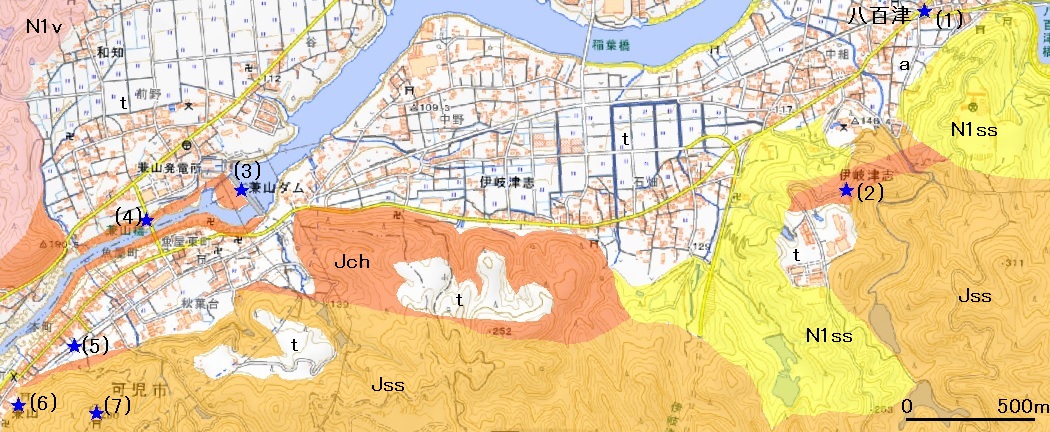
Visit points
(1) Yaotsu
Station remain. A part of rail is
left with a monument.
(2) Chert crops out along a
road, 800 m southwest of the Yaotsu Station. The manganese abandoned mine entrance is
found.
(3) Kaneyama
Dum is seen well from here.
(4)
Chert is exposed near Kaneyama Bridge. Chert is exposed around the Kaneyama Dam site but it is difficult to go down the river.
(5)
Kaneyama Station remain. Area is used a small park.
(6) Tunnel remain near Kaneyama Station.
Geology here is mudstone in Mesozoic.
(7) The castle ruin is trailed
from the Kaneyama Station.
�[�D Mitake, Godo
and Mitakeguchi
General
This area geologically consists
of chert (Jch) and sandstone with mudstone (Jss) in Mino Belt, Cretaceous granite (K2gr), the Nakamura
Formation (N1ss) and the Toki sandy gravel (N3cg). In addition, terrace deposits (t) are
distributed in low lands.
Excursion course is from Mitake through Mitake Forest Park
and Flower Festival Park to Godo or Mitakeguchi.
Long distance route from Mitake through ridge,
Kukuri, Tokai Nature path to JR Shimogiri
is out of the above map area but useful for understanding Miocene stratigraphy.
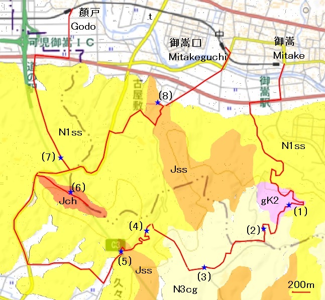
Visit points
(1) Granite is exposed along the road (forest road Maruyama Line) in
the Mitake Forest Park. K feldspar phenocrysts show
1-2cm in long axis. Matrix part of this granite is petrographically
medium-grained granodiorite showing around 10 in color index. The granite intrudes the sandstone
layer. The intrusion contact is N15 ��E in strike and
vertical in dip.
(2) Gravel layer of the Toki Formation crops around the mountain
ridge.
(3) Gravel layer of the Toki Formation crops along the mountain trail.
(4) Mudstone and sandstone of the Nakamura Formation are exposed at
the slope. The Nakamura F. continues along the paved road.
(5) The sandstone of Mesozoic Formation is exposed under the high
voltage electric line in national road 475. Strata show strike of N75 ��W and dip of 75 degrees S.
(6) Mudstone and sandstone
of the Nakamura
F. are locally exposed from the point (5).
After passing the
Flower Festa
Memorial Park
entrance, there
is the mountain
path to a
small Shinto shrine.
The mountain
path is arranged. Cherty rocks are exposed around the
top of the mountain. The rocks are named Wagata Oiwa.
(7) The exposure of the
Nakamura F.
(8) Sandstone intercalating mudstone (Jss)
crops out. Bedded chert is also
exposed.
�\�D Haguro and Gakuden,
Komaki Line (Mt. Owarifuji and Mt. Hongu)
Haguro Station is the nearest
station for Mt. Owari Fuji and Gakuden
Station is the nearest station for Mt. Hongu. Short
courses for either of the two mountains can also be enjoyable.
General
Jurassic accretionary complex and Cretaceous
granite (gK2) crop in the mountainous area. The former is composed of chert (Jch), sandstone with or without mudstone layers (Jss) and mixed rock in mudstone matrix (Jms). Toki gravel (N3cg) is distributed on the
hill. In the lowland, terrace
sediment is distributed on flat plane and alluvium sediment is distributed
along the river valley.
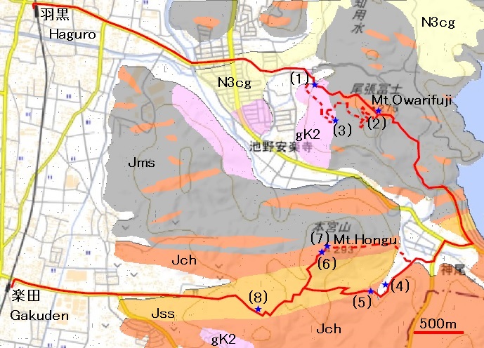
Visit
points
(1)
Omiya-Sengen Shrine. This is start point of the Transport
Stones Festival. Weathered granite
crops out.
(2) At summit of Mt Owari-Fuji,
chert crops out.
(3) Around Ginmei
water spring, granite crops out.
(4) Natural monument �gChionanthus retusus�h
(5) Chert crops out.
(6) Chert is exposed along the path to Mt. Hongu.
(7) Summit of Mt. Hongu.
(8) Sandstone and mudstone are exposed along
the mountain road.
�]�DShin-Unuma, Kagamigahara
Line
The geological section is exposed in the
riverbank of the Kiso River at east of the Meitetsu
Shin-Unuma Station.
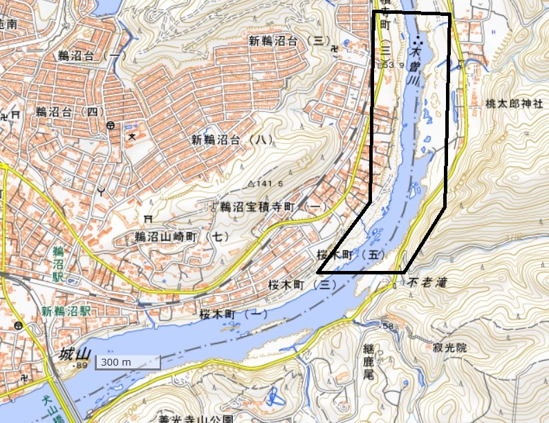
Location map
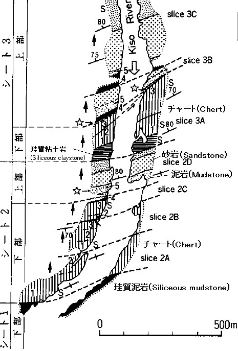
Geological sketch map (Yoshida and Wakita, 1999), showing a frame area of the location map.
Summary
Geology
along the Hiromi Line under the geological framework of Japan.
Japanese Islands is located in the plate subduction
zone, and crustal movement has been active. The record of the past crustal
movement is engraved into the geological feature such as strata and rocks. The history of Japanese Islands for 700
million years can be known by understanding geology. Geology of the Hiromi Line
is overviewed based on the history of this Japanese Islands history.
Base
of Japanese Islands�FAccretionary
Complex
The same geological features are elongating in
the direction of the Japanese Islands. This elongated distribution which has
the same geological features is named "Belt". Each belt is
distinguished by adding geographical name, e.g. �gMino Belt�h. Each belt is the
geological unit which is called the accretionary complex and is formed when the
oceanic plate sinks in the trench. This accretion phenomena have repeated and
Japan has been growing up towards the Pacific.
Jurassic accretion complex is distributed
widely from Hokkaido to Kyushu - Okinawa and makes the base of the Japanese
Islands. The geological unit over the Mino district and the Kiso district is
called Mino Belt or Mino-Tamba Belt which includes Tanba district.
Along the Hiromi Line, Jurassic chert,
sandstone and mudstone of the accretionary complex are exposed in Zenjino, Kanigawa and Mitake. The
completed succession of chert, mudstone and sandstone can be observed along the
Kiso River, in Shin-Unuma, the Kakamigahara
Line.
Cretaceous igneous rocks
Much magma intruded into Japan in Cretaceous, especially
late stage, 100 to 65 Ma. A part of the upper crust was eroded due to passing
long time since late Cretaceous, and the granitic rocks which deeply emplaced
are exposed.
In the Hiromi Line, the Cretaceous granitic
rocks are observed along the Mitake route.
Formation
of the Sea of Japan
Japan had been a part of the continent until
the beginning of Neogene (about 24 Ma).
Dislocation movement happened in the continental margin since this time,
and the continent was disrupted. This was the beginning of Japanese Islands
formation. With this disruption activity, the igneous activity happened. The
volcanic rocks such as basalt and andesite erupted in the wide area of Japan,
and dolerite intruded in underground.
In the Hiromi Line, the pyroclastic rocks such
as lapilli tuff and tuff are exposed along the Kisogawa
River near Kanigawa and Nihonrain-Imawatari
Stations. These are products of the igneous activity at formation of the Sea of
Japan.
Tokai
Lake
The granitic rocks were chemically weathered
under much rain and humid climate from late Miocene to Pliocene (10Ma to 3Ma)
and changed loose materials (Masa), and a large quantity of clay minerals were
generated. The clay was carried out into the downstream by a river at the time.
The Tokai Lake was formed, and a large quantity of clay flowed there and formed
the clay layer. As a result, the Tokai district (Seto
area) has many clay mineral deposits.
The gravel layers are widely distributed at
the hill areas around Mitake and Shinkani
stations. It is sediments of the
Tokai Lake.
Appendix 1
Rock classification and
Geologic time scale
Rock classification Rocks are roughly divided
into �gSedimentary
rocks�h formed by consolidated sediment deposited in
layers, �gIgneous rocks�h formed
by consolidation of a magma, a hot molten mass formed deep in the Earth, and �gMetamorphic rocks�h which are changed from
the pre-existing rocks under a different physical condition.
Sedimentary rocks
Clastic rocks, which are composed of
clastic materials transported by mechanical agent.
Coarse-grained: Conglomerate, Breccia/
Medium-grained: Sandstone/ Fine-grained: mudstone
Organic rocks, which are composed
principally of the remains of plants and animals.�@
Siliceous: Chert, Calcareous:
Limestone, Carbonaceous: Coal
Pyroclastic rocks, which are composed
of fragmented volcanic products.
For example, Lapilli tuff and Tuff
Igneous rocks Igneous rocks are
subdivided into Volcanic rocks and Plutonic rocks.
|
Mafic-Siliceous |
Ultramafic Mafic�@�@�@ Intermediate�@�@�@�@�@�@�@�@Siliceous |
|
SiO2
wt. % |
40
45
52
63
70
75 |
|
Tone of color |
Dark�@ �@- - - - - - - - - - - - - - - - -
- �@Whitish |
|
Volcanic
rocks |
�@�@�@�@�@�@�@�@�@�@�@ Basalt�@�@ Andesite
Dacite
Rhyolite |
|
Plutonic
rocks |
Peridotite
Gabbro Diorite
Granodiorite Granite |
Metamorphic rocks
Contact metamorphism: Metamorphism
related to the intrusion of magmas near the contact.
Hornfels is name of metamorphic rocks
produced by contact metamorphism.
Regional metamorphism: Metamorphism response
to thermal gradient in an extensive area.
Representative rocks are schist and
gneiss. The former readily splits
into thin plate or slabs.
The latter has a banded or coarsely
foliated structure.
Geologic Time Scale
(Ma=mega-annum, million years ago)
|
Era�@�@ |
Period (Epoch)�@ |
Remarks |
|
Cenozoic (66 Ma to today)�@�@�@�@�@ |
Quaternary (Holocene/Pleistocene) Neogene (Pliocene/Miocene) Paleogene (Oligocene/Eocene/Paleocene) |
Homo sapiens (0.25 Ma-) Age of mammals Age of angiospermae |
|
Mesozoic (252 to 66 Ma) |
Cretaceous Jurassic Triassic |
Age of reptiles Age of gymnospermae Ammonoidea |
|
Paleozoic (542 to 252 Ma) |
Permian/Carboniferous/Devonian/Silurian/ Ordovician/Cambrian |
Fusulina Trilobita |
|
Precambrian |
Proterozoic/Archean/Hadean |
Birth of the Earth (4600 Ma) |
Appendix�@2
Geological mapping and Geologic map
The
geologic map shows the distribution of rocks and strata with a color and a
design on the topographical map. It is a required for mineral prospecting, engineering
and disaster prevention.
Preparations
for a geological survey: Carry the rucksack containing some materials on your
back for being both hands free. The tools for geological mapping are a map, a
notebook, writing implements, a hammer, a clinometer and a loupe (or insect
glasses). A plastic bag or an old newspaper may be useful for sample
collections.
A
geological survey: Observe geological feature of strata and rocks. You write
down the location name in the notebook and the location point on the map. You
write latitude and longitude if you can know. You should measure strike and dip
of strata of a sedimentary rock.
Strike
and dip: You will distinguish the border of the stratum in difference of grain
size and composition. The boundary surface is called a stratification plane.
The direction, an intersection of the stratification plane and the horizontal
plane is a strike and the angle between two planes is dip.
A
geologic map: If there are many strata data, you can draw a geological feature
border by freehand. Mostly you presume a geologic border geometrically.
Appendix�@3
Manganese ore
deposits
Manganese ore deposits,
including small mines in the Hiromi Line area, are overviewed for understanding
Mineral Resource Economics in Japan.
Mining
activities in Japan (Hirowatari, 1980)
In middle of
19th century, manganese was used for dyes, medicine, coloring glass
and dry battery.
In end of 19th
century to early 20th century, manganese was used for iron and steel
manufactures.
During First World
War, manganese mining accelerated developing of iron and steel manufactures.
During 1920
to 1924, the mining suffered.
In 1931
(Manchuria Incident) to 1944 (Second War), the manganese mining was golden age.
For example,
340 to 350 thousand tons a year in 1943 and 1944.
In 1945 to
1948, the mining was dull.
In 1950,
there is the steel industry demand in Korea disturbance.
From
1958 to 1959, it is 350,000 tons of yearly output, the second golden age again
In the 1960s,
the mining production fail to rise by trade liberalization.
In 1973, the
mines were closed successively due to the oil crisis,
The manganese
mines which we can visit at the present
�EThe
Noda Tamakawa Mine, Iwate, is released as a
sightseeing mine (Marine Rose Park).
�EThe new
Otani mine, Kyoto, is released as a sightseeing mine.
Recent
manganese circumstances (JOGMEC�C 2018)
Manganese use: Most of demand, 97%, are used for
deoxidation, the desulfurization of steel materials as raw materials and
ferromanganese of the manganese steel.
In addition, manganese is
used the anode of a manganese battery and the lithium battery, canned aluminum
drink, an alloy and am used for a ferrite magnet. Potassium permanganate is used for an
analysis reagent, organic composition, sterilization, gunpowder and pharmaceutical
products.
Production
country (2017) unit
material 1000 tons
China 25,000
South Africa 14,358
Gabon
4,163
Australian 4,065
Ghana
2,662
�@ Others
Total 61,163
Ore import
country for Japan�@unit
1000 pure tons
South Africa 250.9
Australian 89.9
Gabon
75.1
�@�@Others
Total 416.2
Appendix 4�@
Underground
geological information
The ground
information such as drilling columnar sections or the soil quality test data is
summarized by the Ministry of Land, Infrastructure, Transport and Tourism based
on investigation data in national land developing projects. This information site is called �gKuniJiban�h.
A search site�Fhttp://www.kunijiban.pwri.go.jp/jp/index.html
Enter the
search site "Using ground information site KuniJiban".
Then move a map to the target area and point out in detail on extended
map. Bowling data will be appeared
from data points.
Along the
Hiromi Line, there are many drilling data along Route 41 and Route 21,
particularly much near Kani-Mitake IC. A red mark in
the map shows the location of drilling. The data ID and investigation outline
are shown after clicking the target place. Furthermore, the data in a columnar
section can be readable. The depth from the surface to a geological unit can be
known, and the iso-depth counter map to the geological unit can be prepared.
Example:
South of Mitake Station, Route 21 (ID:
B4KJ201801005-1560)
Depth from
surface (m) Geology Abbreviation Geologic unit
0 – 1 soil
1 – 4 gravel a
or t Alluvium
or Terrace deposits
4 – 47 sandstone and mudstone N1ss Nakamura
Formation
(20 – 47) often
lignite interbedded
in N1ss
47 – 48.3 tuff N1v Hachiya Formation
References
Adachi, M., Kojima, S., Wakita,
K., Suzuki, K. and Tanaka, T., 1992, Transect of central Japan: From Hida to Shimanto. 29th IGC Field Trip Guide Book, 1, 143-178.
Ground Information site, Ministry
of Land, Infrastructure, Transport and Tourism.
http://www.kunijiban.pwri.go.jp/jp/index.html
GSJ, AIST�C2017�CSeamless geological
map of Japan in scale 1: 200,000, ver. 2, AIST.
Hirowatari, F., 1980, Historical
Review of the Studies and Geological Surveys of the Bedded Manganese Ore
Deposits in Japan. Jour. Min. Petr.
Econ. Geol., special vol. 2, 151-164.
Itoigawa, J., 1983, �USurface Geology, �gGifu, Minokamo, Seto�h in scale 1:50,000.
Aichi Prefecture, 44-61.
JOGMEC (2018)�FMineral Resources Flow 2018,
16 Manganese, 1-18.
Kiyono, N. and Ishi, K.,
1927, Tajimi.
Geological map in scale 1: 75,000, GSJ.
Nagoya Rail Way, 1994, The commemoration for
100 years anniversary. Nagoya Rail
Way, 1106 p.
Nozaki, T., Fujinaga,
K. and Kato, Y., 2018, Ore deposit formed on a paleo-seafloor in the Japanese
accretionary complex. Jour Geol.
Soc. Japan, 124, 995-1020.
Sakamoto, T., Kuwahara,
T., Itoigawa, J., Takada, Y., Wakita,
K. and Onoe, T., 1984, Geology of the Nagoya-Hokubu District.
Quadrangle Series, scale 1: 50,000.
GSJ, 64 p.
Shinjo, H., Furukawa, K., Orihashi, Y., Hokanishi, N. and
Wada, Y. 2018, Zircon U-Pb Ages of Tochibora welded
tuff Member at the lowe most part of the Hachiya Formation, in Kani Basin,
Gifu Prefecture. Jour. Geol. Soc.
Japan, 124, 533-538.
Sudo, S., 2000, Industrial
minerals �f99 of Tokai area, Central Japan. Chishitsu
(Geology) News, no. 552, 23-29.
Ueki, T., Niwa, M., Iwano, H., Danhara, T. and
Hirata, T., 2019, Zircon U-Pb and Fission-track ages for the Ohta Tephra in the Pliocene Tokai Group, Central Japan. Jour. Geol. Soc. Japan, 125, 227-236.
Wakita, K., 1988, Origin of
chaotically mixed rock bodies in the Early Jurassic to Early Cretaceous
sedimentary complex of the Mino terrane, central Japan. Bull. Geol. Surv.
Japan, 39, 675-757.
Yamada, N., Wakita,
K., Hiroshima, T. and Komazawa, M., 1990, Iida
(second edition). Geologic map in
scale 1: 200,000, GSJ.
Yoshida, F. and Wakita,
K., 1999, Geology of the Gifu District.
Quadrangle Series, scale 1: 50,000.
GSJ, 71 p.
--------------------------------------------------------
Geology along Hiromi Line
April 1, 2021
Published by Inuyama
Research Center, Nagoya University of Economics
61-1 Uchikubo, Inuyama, Aichi 484-8504, Japan
Bibliographic reference
Inuyama Research Center,
Nagoya University of Economics (2021) Geology along Hiromi Line. Nagoya University of Economics, leaflet.
Staff and charge�F
Supervision Adachi,
M.
Field survey Takahashi,
Y.
Meitetsu Itou, H.
Train geology Fujita,
M.
Digital mapping Naito, K.
Coordination Nakamura,
M.